


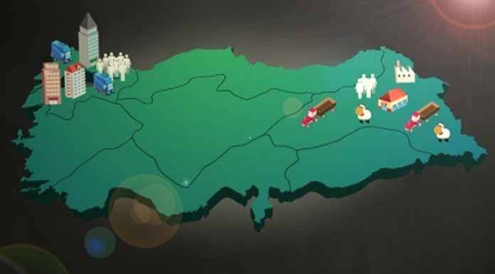
Eighty-one people per square kilometer. That was Turkey’s average population density back in the 1997 census. On paper, it sounds manageable. In reality, the number tells only half the story. Look at a map. The distribution is anything but uniform. Some areas feel suffocated by crowds. Others remain eerily empty.
Why does this happen? It isn’t random. Geography and human activity collide to shape where people actually live. The differences between regions, sub-regions, and districts aren’t just statistical noise. They are the direct result of physical and human factors working in tandem.
The Weight of Physical Geography
Nature sets the stage. Mountains, coastlines, and climate dictate where building is even possible.
People naturally cluster in places that offer survival advantages. Water, mild weather, and flat land are not luxuries; they are prerequisites for dense settlements.
In Turkey, the physical landscape is a mix of rugged highlands and fertile plains. The Taurus Mountains block easy access to the southern coast. The Anatolian plateau sits high and dry. These physical barriers create natural zones of exclusion. You cannot simply pave over a mountain range and expect a city to bloom. The soil quality matters too. Volcanic soils in central Anatolia support agriculture. Rocky, arid soils in parts of eastern Turkey do not.
Human Choices Drive Density
Physical factors set the limits. Human factors determine how those limits are used.
Economic opportunities pull people toward urban centers. Istanbul and Ankara are not just political or geographic labels. They are economic engines. Jobs, infrastructure, and services create gravity. People move toward them. This is the human factor in action.
Historical settlement patterns also play a role. Coastal regions have traded for millennia. Ports attract commerce. Commerce attracts workers. Rural areas, especially in the east, face different pressures. Lack of industrial investment leads to out-migration. Younger generations leave for better prospects in the west.
Bridging the Gap
Understanding these drivers helps explain the imbalance. It is not just about where people are. It is about why they are there.
- Physical barriers like mountains restrict expansion.
- Climate influences agricultural viability.
- Economic hubs create density through job concentration.
- Infrastructure connects or isolates communities.
The 1997 data is old. The trend, however, persists. Urbanization continues. Rural depopulation accelerates in many areas. The gap between the crowded coast and the empty interior remains a defining feature of the country.
So, what does this mean for you? If you are planning to move, study, or invest, look beyond the average. Look at the local context. What physical features define the area? What human factors are driving growth or decline? The answers will tell you more than any national statistic ever could.
The story of where we live is still being written. And it is far from over.
The map of Turkey isn’t random. It’s a chart of where people can survive easily and where they have to fight for it. Two main forces drive this pattern. Physical geography sets the stage. Human activity writes the script.
How Climate Dictates Where People Live
Look at the weather maps. Look at where the houses are. They overlap.
People flock to places where the air doesn’t try to kill them. This is why the Mediterranean, Aegean, and Marmara regions are packed. Winters are mild. Summers are hot, sure, but not dry enough to ruin farming or daily life. The Black Sea coast joins them, thanks to moisture and moderate temperatures.
Contrast that with Eastern Anatolia. Take Kars, Erzurum, Ardahan, or Iğdır. Here, the climate is harsh. Summers are dry. Winters are brutal. It’s hard to grow food in frozen ground. It’s hard to travel when roads are blocked by snow. So, fewer people live there. The physical barrier is the air itself.
Why Rugged Terrain Keeps Populations Low
Mountains don’t just look pretty. They block progress.
In Eastern Anatolia, the land is steep and broken. The Taşeli Plateau and Menteşe region are riddled with uneven terrain. Try farming on a slope. Try building a road through a canyon. It’s expensive and difficult. If you can’t bring in goods or send out crops, you can’t sustain a large town. That’s why these rugged areas have sparse populations. Nature demands a high cost for settlement here.
The Role of Soil in Settlement Density
You can’t eat scenery. You need soil.
Fertile land is the single biggest magnet for people. Look at the Çukurova, Gediz, and Büyük Menderes plains. The ground there is rich. It yields crops year after year. This abundance supports large communities. It supports the economies that feed them.
Compare that to rocky, arid patches where farming fails. Those areas stay empty. Or mostly empty. The soil determines the ceiling for population growth.
Human Factors: Why We Choose Certain Cities
Physical factors set the limits. Human factors fill the spaces.
People follow opportunity. They follow comfort. In Turkey, this means moving toward jobs, services, and infrastructure. Five human drivers explain most of the urbanization:
- Industrialization
- Agriculture
- Underground resources
- Tourism
- Transportation
Industrialization as a Population Engine
Factories create jobs. Jobs create cities.
This rule holds true everywhere. In Turkey, it’s obvious in the big hubs. Istanbul, Izmit, Adapazarı, Bursa, Adana, and Izmir are dense because they work. They offer better living standards. They offer careers.
Look at Eastern Anatolia or parts of the Southeastern Anatolia and Black Sea regions again. Fewer factories. Fewer jobs. People leave or don’t arrive in large numbers. The lack of industrialization is a vacuum. It pulls population away.
Agriculture’s Pull on Rural Populations
Farming requires hands. Lots of them.
Where arable land exists, people stay. Or move there. The Çukurova, Gediz, Bafra, and Çarşamba plains are agricultural powerhouses. They feed millions. They support thousands of farmers and related businesses. High agricultural output equals high local population density. It’s a direct link. No complex theory needed.
Mining Towns and Resource Wealth
Underground wealth brings people above ground.
Where energy and minerals are found, jobs follow. Zonguldak (coal), Soma (coal), and Elbistan (lignite) are prime examples. These towns grew because the earth provided something valuable. Workers moved in. Families followed. The presence of underground resources created self-sustaining communities that might not exist otherwise.
Tourism: A Unique Population Driver
Some places grow because of visitors.
The Aegean and Mediterranean coasts are huge. Is it just farming there? No. The Mediterranean, in particular, relies heavily on tourism. While some areas have good soil, the real engine is the service sector tied to travel. Hotels, restaurants, transport, entertainment. Tourism creates millions of jobs. It draws people to the coast in a way that pure agriculture never could. It’s a human-made factor with massive geographic impact.
Transportation: The Artery of Urban Growth
If you can get there easily, you go there.
Transportation networks dictate flow. Eskişehir, Ankara, Kayseri, and Istanbul are major hubs not just by accident. They are connected. Roads, rails, airports. Trade moves faster. People move faster. Life becomes easier. This convenience attracts businesses and residents alike. Poor transport infrastructure? That area stagnates. The link between mobility and population density is undeniable.
The Shift from Physical to Human
Historically, nature dictated where we lived. Mountains stopped us. Rivers fed us.
Today, economics dictate where we cluster. Industrialization and human development have shifted the balance. A country with strong economic and human factors will see population concentrate in specific zones, regardless of harsh physical conditions nearby. The map is changing. It’s becoming a map of opportunity, not just survival.
Reading the Density Map
If you look at a current Turkey population distribution map, the patterns hold.
The heavyweights are clear. Istanbul, Ankara, Izmir, Bursa, Antalya (İçel), Adana, Gaziantep, İzmit, Adapazarı, Trabzon, Samsun, Zonguldak, Aydın, and Hatay. These are the anchors. They have the jobs, the transport, or the tourism.
The empty spaces are just as telling. Sinop, Kastamonu, Artvin, Gümüşhane, Kırklareli, Çanakkale, Muğla, Kütahya, Burdur, Sivas, and much of Eastern Anatolia (except Elazığ and Malatya ) remain sparse. The reasons are still the same. Tough terrain. Poor soil. Lack of industry. Distance from markets.
The story of where we live is still being written by the land. But it’s increasingly being edited by our economy.


